ASI – Impact of Autonomous Vehicles
This study explored various ways autonomous and connected vehicles can be used to help the vulnerable communities in Atlanta, particularly in satisfying the human basic needs for biological, physiological, and safety needs. We used Python, Tableau and GIS in this project.
We approach our analysis in the following ways:
- understanding the current state of autonomous vehicles along with near-term projections,
- the distribution of fatalities among different segments of our population,
- identifying the most vulnerable segments of our population that could benefit from access to autonomous vehicles by considering basic needs such as food and healthcare,
- identifying current projects focused on autonomous vehicles preparedness that can help Georgia success at this important mission.
Autonomous Vehicle Background and Projections
The demand for autonomous vehicles (AVs) are expected to increase by a CAGR (compounded annual growth rate) of 63% from 2021 to 2030. In the US, AVs are valued over $3B in 2020 and are forecasted to grow to over $8B by 2026. As the technology improves and becomes more accessible and available, it can be used to level the playing field for disadvantaged and vulnerable populations in the community.
We analyzed distribution of motor vehicle fatalities by educational attainment and race. Higher educational attainment seems to have more fatalities while less than high school education actually has the lowest. The breakdown by race also shows that the majority of the fatalities are White, accounting for 60% of the total motor vehicle deaths.
Motor Vehicle Fatalities Population Segmentation Analysis
Deaths by motor vehicle crashes accounted for almost 2% of total deaths in 2019. By county, most of the deaths are from Fulton, Dekalb, Cobb and Gwinnett, which altogether represent 23% of the total motor vehicle fatalities in Georgia. This is not surprising because these four are also the most populous counties in Georgia.

Autonomous Vehicles and Food Access
We identified that food stamp recipients are a vulnerable and underserved segment of our community that could benefit greatly from autonomous vehicle technology. Specifically, autonomous vehicle technology could facilitate and make accessible transportation to/from the grocery store as well as as a grocery delivery service.
We looked into the 12 vulnerable counties in Georgia where at least 10% of the total households are food stamps recipients, and cross-analyzed it against the rate of car ownership. Georgia overalls has an average of 6.2% food stamps recipients, and 2.6% non-car owners. Altogether, the 12 vulnerable counties have an average of 11.2% food stamps recipients, and 4.6% non-car owners, way above the Georgia average. These counties are primarily located on the southern side of Georgia and in rural areas.

Autonomous Vehicles and Access to Healthcare
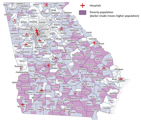
Finally, we looked at the poverty level and hospital placement by county. From the figure below, the darker the shade, the higher the poverty population is. The red crosses represent hospitals. As we can see, there are several hospitals in the metro area with lower presence of poverty population, while we observe the opposite in South Georgia. Residents of poorer counties have limited access to hospitals, and that problem is exasperated if there is no reliable car access.
Summary and Next Steps
Autonomous vehicles readiness depends heavily on use of data to activate insights and, therefore, a working data system must be established. The existence of an effective data system would bring more data visibility, which could be applied into other projects and organizations. The Atlanta Regional Commission already has an open resource data platform called Neighborhood Nexus. It could be used as the main platform to provide and share data and projects.
Aside from having an effective data platform, basic infrastructure and planning is required. For example, defining the test areas/lanes for AV, improving road conditions, installing LED smart streetlights and smart cameras with sensors, and implementing license plate recognition technology and regulation. This is currently being done in the Curiosity Lab Corridor Project at Peachtree Corners (Georgia). Similar work is being performed by the Smart Columbus Project in Ohio, the first-ever smart city challenge winner of the US Department of Transportation. Atlanta and the Georgia overall can get learnings and inspiration from these projects.
More Details: